


Siljan WorldWind.jpg
Från Skolbok

Storlek på förhandsvisningen: 600 × 600 pixlar. Andra upplösningar: 240 × 240 pixlar | 480 × 480 pixlar | 640 × 640 pixlar.

Originalfil (640 × 640 pixlar, filstorlek: 111 kbyte, MIME-typ: image/jpeg)
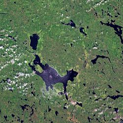
| Beskrivning | Siljan impact crater. Several lakes trace the remnants of the eroded impact crater that was formed by a meteorite impact about 370 million years ago. With a diameter of 55 km it is the largest impact structure in Europe. Lake Siljan is the large lake in the south of the ring. |
| Källa | Created with NASA WorldWind by User:Vesta using Landsat 7 (Visible Color) satellite image. |
| Skapare | User:Vesta |
61°2′20″N 14°55′10″E / 61.0389°N 14.9194°E

 |
This image is in the public domain because it is a screenshot from NASA’s globe software World Wind using a public domain layer, such as Blue Marble, MODIS, Landsat, SRTM, USGS or GLOBE.
|
 |
Filhistorik
Klicka på ett datum/klockslag för att se filen som den såg ut då.
| Datum/Tid | Miniatyrbild | Dimensioner | Användare | Kommentar | |
|---|---|---|---|---|---|
| nuvarande | 7 januari 2006 kl. 09.32 | | 640 × 640 (111 kbyte) | wikimediacommons>Vesta~commonswiki | *'''Description:''' Siljan impact crater. Several lakes trace the remnants of the eroded impact crater that was formed by a meteorite impact about 370 million years ago. With a diameter of 55 km it is the largest impact structure in Europe. Lake Siljan is |
Filanvändning
Följande sida använder den här filen:
